Lüschersee Tschappina
Permanent GNSS monitoring of a natural lake during the re-filling process

In 1910, the water of the natural Lüschersee lake above Tschappina was drained because it was suspected to be connected to the landslides on the Heinzenberg. In 2019, the lake is to be refilled to investigate whether the lake is sufficiently sealed to ensure that there is enough water at the beginning of winter to serve as a reservoir for a technical snow-making system for the Tschappina-Lüsch-Urmein ski lifts.
Three selected locations have been monitored using GNSS to investigate any slope movements during the reactivation of the lake.
The autonomous, solar-powered measuring systems enabled the project managers to reliably and continuously monitor the movements of the terrain at the sensor locations in the low millimetre range.
Services
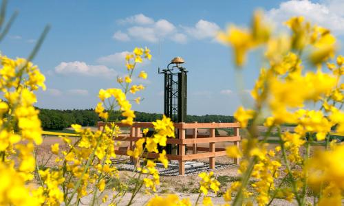
- Delivery, installation and commissioning of 4 TEDAMOS GNSS Pro sensors
- Automatic monitoring with high-precision daily solutions (< 3 mm in position)
- Online access to current measurement values on a web-based customer portal
Technologies
- 4 solar-powered, autonomous TEDAMOS GNSS Pro sensors
- TEDAMOS Web, password-protected customer portal with 24/7 access
More reference projects
Lüschersee Tschappina
Tschappina, Switzerland
Permanent GNSS monitoring of a natural lake during the re-filling process


Renovation of the Palace Hotel, Luzern
Automatic height monitoring with hose levelling and tachymeter

New Building GLC, ETH Zurich
Geodetic and geotechnical permanent monitoring of a deep excavation pit
NaGNet GPS Monitoring
Long-term monitoring to detect local movements in the earth's crust